


Pic St michel

lionelnottat
User
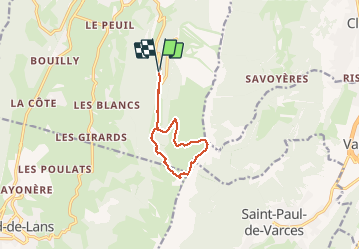

Length
9.4 km

Max alt
1965 m

Uphill gradient
661 m
Km-Effort
18.2 km

Min alt
1275 m

Downhill gradient
658 m
Boucle
Yes
Creation date :
2019-06-03 16:31:30.94
Updated on :
2019-06-03 16:32:32.701
3h38
Difficulty : Difficult

FREE GPS app for hiking
 SityTrail
IGN / Geographical institutes
SityTrail Plus
The world is yours!
About
Trail Walking of 9.4 km to be discovered at Auvergne-Rhône-Alpes, Isère, Lans-en-Vercors. This trail is proposed by lionelnottat.
Positioning
Country:
France
Region :
Auvergne-Rhône-Alpes
Department/Province :
Isère
Municipality :
Lans-en-Vercors
Location:
Unknown
Start:(Dec)
Start:(UTM)
704793 ; 4998287 (31T) N.
Comments