


durtol

DANBRU
User
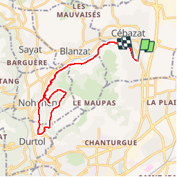

Length
15.9 km

Max alt
566 m

Uphill gradient
256 m
Km-Effort
19.3 km

Min alt
343 m

Downhill gradient
251 m
Boucle
Yes
Creation date :
2019-06-03 11:16:53.563
Updated on :
2019-06-03 18:06:02.938
4h22
Difficulty : Very easy

FREE GPS app for hiking
 SityTrail
IGN / Geographical institutes
SityTrail Plus
The world is yours!
About
Trail Walking of 15.9 km to be discovered at Auvergne-Rhône-Alpes, Puy-de-Dôme, Cébazat. This trail is proposed by DANBRU.
Positioning
Country:
France
Region :
Auvergne-Rhône-Alpes
Department/Province :
Puy-de-Dôme
Municipality :
Cébazat
Location:
Unknown
Start:(Dec)
Start:(UTM)
508149 ; 5074388 (31T) N.
Comments