


germagny 2018 06 04

desbois
User
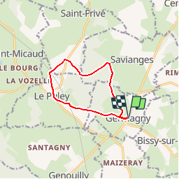

Length
9.4 km

Max alt
400 m

Uphill gradient
231 m
Km-Effort
12.5 km

Min alt
246 m

Downhill gradient
233 m
Boucle
Yes
Creation date :
2019-06-04 15:48:01.108
Updated on :
2019-06-04 15:52:13.119
2h39
Difficulty : Medium

FREE GPS app for hiking
 SityTrail
IGN / Geographical institutes
SityTrail Plus
The world is yours!
About
Trail Walking of 9.4 km to be discovered at Bourgogne-Franche-Comté, Saône-et-Loire, Germagny. This trail is proposed by desbois.
Description
gr3 9.4km 230m de denivele
Positioning
Country:
France
Region :
Bourgogne-Franche-Comté
Department/Province :
Saône-et-Loire
Municipality :
Germagny
Location:
Unknown
Start:(Dec)
Start:(UTM)
622565 ; 5169817 (31T) N.
Comments