


ambel

guy07
User
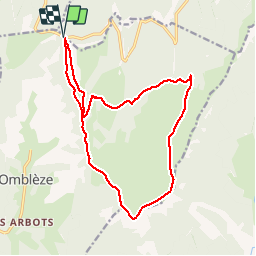

Length
17 km

Max alt
1501 m

Uphill gradient
611 m
Km-Effort
25 km

Min alt
1197 m

Downhill gradient
610 m
Boucle
Yes
Creation date :
2019-06-04 08:19:00.003
Updated on :
2019-06-05 06:09:20.287
6h26
Difficulty : Very easy

FREE GPS app for hiking
 SityTrail
IGN / Geographical institutes
SityTrail Plus
The world is yours!
About
Trail Walking of 17 km to be discovered at Auvergne-Rhône-Alpes, Drôme, Omblèze. This trail is proposed by guy07.
Positioning
Country:
France
Region :
Auvergne-Rhône-Alpes
Department/Province :
Drôme
Municipality :
Omblèze
Location:
Unknown
Start:(Dec)
Start:(UTM)
676340 ; 4974049 (31T) N.
Comments