


RS-Mury

raymondfn
User

Length
5.4 km

Max alt
421 m

Uphill gradient
27 m
Km-Effort
5.8 km

Min alt
398 m

Downhill gradient
28 m
Boucle
Yes
Creation date :
2019-06-05 12:05:38.5
Updated on :
2020-01-13 16:42:29.483
1h17
Difficulty : Easy

FREE GPS app for hiking
 SityTrail
IGN / Geographical institutes
SityTrail Plus
The world is yours!
About
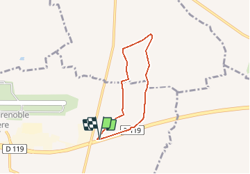
Trail Walking of 5.4 km to be discovered at Auvergne-Rhône-Alpes, Isère, Saint-Étienne-de-Saint-Geoirs. This trail is proposed by raymondfn.
Description
Les chemins qui contournent le bois de Mury n'existent pas (ils ne figurent pas au cadastre).
Le passage dans le bois (Mury) est absent sur 100 m, on peut passer en zigzagant...
Positioning
Country:
France
Region :
Auvergne-Rhône-Alpes
Department/Province :
Isère
Municipality :
Saint-Étienne-de-Saint-Geoirs
Location:
Unknown
Start:(Dec)
Start:(UTM)
684657 ; 5025277 (31T) N.
Comments