


Lamure-sur-Arzegues

Thomasdanielle
User
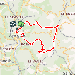

Length
16 km

Max alt
836 m

Uphill gradient
596 m
Km-Effort
24 km

Min alt
383 m

Downhill gradient
596 m
Boucle
Yes
Creation date :
2019-06-06 07:00:16.0
Updated on :
2019-06-06 13:28:41.518
5h43
Difficulty : Unknown

FREE GPS app for hiking
 SityTrail
IGN / Geographical institutes
SityTrail Plus
The world is yours!
About
Trail Walking of 16 km to be discovered at Auvergne-Rhône-Alpes, Rhône, Lamure-sur-Azergues. This trail is proposed by Thomasdanielle.
Description
Jhhj
Positioning
Country:
France
Region :
Auvergne-Rhône-Alpes
Department/Province :
Rhône
Municipality :
Lamure-sur-Azergues
Location:
Unknown
Start:(Dec)
Start:(UTM)
615471 ; 5102194 (31T) N.
Comments