Moussy du 06/06/2019

VANDERPUTTENMi
User GUIDE

Length
21 km

Max alt
238 m

Uphill gradient
407 m
Km-Effort
26 km

Min alt
90 m

Downhill gradient
408 m
Boucle
Yes
Creation date :
2019-06-06 07:45:51.251
Updated on :
2019-06-06 14:26:32.681
5h49
Difficulty : Very easy

FREE GPS app for hiking
 SityTrail
IGN / Geographical institutes
SityTrail Plus
The world is yours!
About
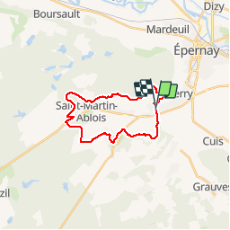
Trail Walking of 21 km to be discovered at Grand Est, Marne, Moussy. This trail is proposed by VANDERPUTTENMi.
Positioning
Country:
France
Region :
Grand Est
Department/Province :
Marne
Municipality :
Moussy
Location:
Unknown
Start:(Dec)
Start:(UTM)
567392 ; 5429240 (31U) N.
Comments