


La castagnica Strada

bruno49120
User
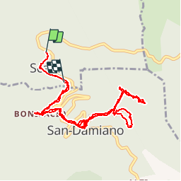

Length
6.9 km

Max alt
734 m

Uphill gradient
277 m
Km-Effort
10.6 km

Min alt
511 m

Downhill gradient
266 m
Boucle
No
Creation date :
2014-12-10 00:00:00.0
Updated on :
2014-12-10 00:00:00.0
2h19
Difficulty : Easy

FREE GPS app for hiking
 SityTrail
IGN / Geographical institutes
SityTrail Plus
The world is yours!
About
Trail Walking of 6.9 km to be discovered at Corsica, Haute-Corse, Scata. This trail is proposed by bruno49120.
Positioning
Country:
France
Region :
Corsica
Department/Province :
Haute-Corse
Municipality :
Scata
Location:
Unknown
Start:(Dec)
Start:(UTM)
533128 ; 4696278 (32T) N.
Comments