


20190606 Boves

Childebert
User
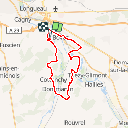

Length
23 km

Max alt
103 m

Uphill gradient
303 m
Km-Effort
27 km

Min alt
25 m

Downhill gradient
302 m
Boucle
Yes
Creation date :
2019-06-06 07:34:55.566
Updated on :
2019-06-07 19:11:33.79
7h03
Difficulty : Medium

FREE GPS app for hiking
 SityTrail
IGN / Geographical institutes
SityTrail Plus
The world is yours!
About
Trail Walking of 23 km to be discovered at Hauts-de-France, Somme, Boves. This trail is proposed by Childebert.
Positioning
Country:
France
Region :
Hauts-de-France
Department/Province :
Somme
Municipality :
Boves
Location:
Unknown
Start:(Dec)
Start:(UTM)
455397 ; 5521622 (31U) N.
Comments