


gervans 2

jojomarette
User
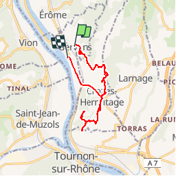

Length
14 km

Max alt
338 m

Uphill gradient
423 m
Km-Effort
19.7 km

Min alt
121 m

Downhill gradient
442 m
Boucle
No
Creation date :
2019-06-08 08:20:32.238
Updated on :
2019-06-08 14:09:55.056
5h43
Difficulty : Very easy

FREE GPS app for hiking
 SityTrail
IGN / Geographical institutes
SityTrail Plus
The world is yours!
About
Trail Walking of 14 km to be discovered at Auvergne-Rhône-Alpes, Drôme, Gervans. This trail is proposed by jojomarette.
Description
Très beau
Positioning
Country:
France
Region :
Auvergne-Rhône-Alpes
Department/Province :
Drôme
Municipality :
Gervans
Location:
Unknown
Start:(Dec)
Start:(UTM)
644135 ; 4996640 (31T) N.
Comments