


2019 06 09 germagny

desbois
User
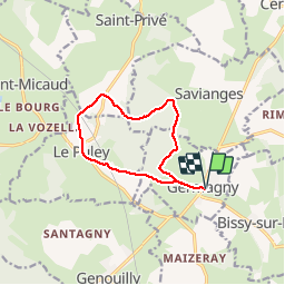

Length
10.3 km

Max alt
401 m

Uphill gradient
249 m
Km-Effort
13.6 km

Min alt
247 m

Downhill gradient
248 m
Boucle
Yes
Creation date :
2019-06-09 07:56:47.434
Updated on :
2019-06-09 10:16:43.633
2h19
Difficulty : Very easy

FREE GPS app for hiking
 SityTrail
IGN / Geographical institutes
SityTrail Plus
The world is yours!
About
Trail Walking of 10.3 km to be discovered at Bourgogne-Franche-Comté, Saône-et-Loire, Germagny. This trail is proposed by desbois.
Description
Gr 3 10.3km. 250m de Dénivelé
Positioning
Country:
France
Region :
Bourgogne-Franche-Comté
Department/Province :
Saône-et-Loire
Municipality :
Germagny
Location:
Unknown
Start:(Dec)
Start:(UTM)
622648 ; 5169788 (31T) N.
Comments