


Brantes Toulourenc

Nathy8913
User
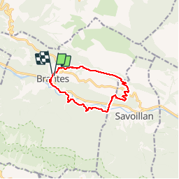

Length
10.8 km

Max alt
826 m

Uphill gradient
461 m
Km-Effort
16.9 km

Min alt
472 m

Downhill gradient
446 m
Boucle
Yes
Creation date :
2019-06-09 07:00:26.991
Updated on :
2019-06-09 13:14:39.598
4h54
Difficulty : Medium

FREE GPS app for hiking
 SityTrail
IGN / Geographical institutes
SityTrail Plus
The world is yours!
About
Trail Walking of 10.8 km to be discovered at Provence-Alpes-Côte d'Azur, Vaucluse, Brantes. This trail is proposed by Nathy8913.
Positioning
Country:
France
Region :
Provence-Alpes-Côte d'Azur
Department/Province :
Vaucluse
Municipality :
Brantes
Location:
Unknown
Start:(Dec)
Start:(UTM)
686563 ; 4896092 (31T) N.
Comments