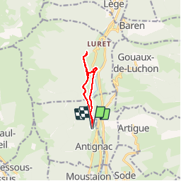
Luchon Pradette

josy31
User

Length
8 km

Max alt
721 m

Uphill gradient
222 m
Km-Effort
10.9 km

Min alt
589 m

Downhill gradient
222 m
Boucle
Yes
Creation date :
2019-06-09 11:14:14.574
Updated on :
2019-06-09 14:04:43.873
2h01
Difficulty : Very easy

FREE GPS app for hiking
 SityTrail
IGN / Geographical institutes
SityTrail Plus
The world is yours!
About
Trail Walking of 8 km to be discovered at Occitania, Haute-Garonne, Antignac. This trail is proposed by josy31.
Positioning
Country:
France
Region :
Occitania
Department/Province :
Haute-Garonne
Municipality :
Antignac
Location:
Unknown
Start:(Dec)
Start:(UTM)
303816 ; 4744942 (31T) N.
Comments