


chassey le camp Dheune

mcterret
User
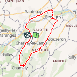

Length
16.4 km

Max alt
429 m

Uphill gradient
371 m
Km-Effort
21 km

Min alt
208 m

Downhill gradient
371 m
Boucle
Yes
Creation date :
2019-06-09 07:29:18.384
Updated on :
2019-06-09 14:48:19.684
5h52
Difficulty : Easy

FREE GPS app for hiking
 SityTrail
IGN / Geographical institutes
SityTrail Plus
The world is yours!
About
Trail Walking of 16.4 km to be discovered at Bourgogne-Franche-Comté, Saône-et-Loire, Chassey-le-Camp. This trail is proposed by mcterret.
Positioning
Country:
France
Region :
Bourgogne-Franche-Comté
Department/Province :
Saône-et-Loire
Municipality :
Chassey-le-Camp
Location:
Unknown
Start:(Dec)
Start:(UTM)
629321 ; 5194097 (31T) N.
Comments