


Sentier des Mineurs

denissculier
User
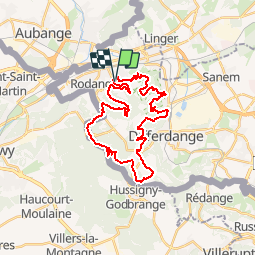

Length
29 km

Max alt
433 m

Uphill gradient
643 m
Km-Effort
38 km

Min alt
289 m

Downhill gradient
649 m
Boucle
Yes
Creation date :
2019-06-10 07:09:40.962
Updated on :
2019-06-10 07:12:37.772
1m
Difficulty : Very difficult

FREE GPS app for hiking
 SityTrail
IGN / Geographical institutes
SityTrail Plus
The world is yours!
About
Trail Nordic walking of 29 km to be discovered at Unknown, Canton Esch-sur-Alzette, Pétange. This trail is proposed by denissculier.
Positioning
Country:
Luxembourg
Region :
Unknown
Department/Province :
Canton Esch-sur-Alzette
Municipality :
Pétange
Location:
Unknown
Start:(Dec)
Start:(UTM)
706473 ; 5491961 (31U) N.
Comments