


tiergues 1

CASSISFRAMBOISE
User
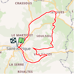

Length
19 km

Max alt
649 m

Uphill gradient
449 m
Km-Effort
25 km

Min alt
327 m

Downhill gradient
452 m
Boucle
Yes
Creation date :
2019-06-13 08:38:27.692
Updated on :
2019-06-13 14:26:17.612
4h57
Difficulty : Easy

FREE GPS app for hiking
 SityTrail
IGN / Geographical institutes
SityTrail Plus
The world is yours!
About
Trail Walking of 19 km to be discovered at Occitania, Aveyron, Saint-Affrique. This trail is proposed by CASSISFRAMBOISE.
Description
voie verte puis vaihauzy ...la quille et Tiergues. Retour par vallon de Baldassė.
Positioning
Country:
France
Region :
Occitania
Department/Province :
Aveyron
Municipality :
Saint-Affrique
Location:
Unknown
Start:(Dec)
Start:(UTM)
490828 ; 4867388 (31T) N.
Comments