


genets-pontaubault

fhascoet
User
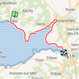

Length
23 km

Max alt
24 m

Uphill gradient
112 m
Km-Effort
24 km

Min alt
0 m

Downhill gradient
107 m
Boucle
No
Creation date :
2019-06-13 08:27:24.192
Updated on :
2019-06-13 14:49:32.678
5h52
Difficulty : Very easy

FREE GPS app for hiking
 SityTrail
IGN / Geographical institutes
SityTrail Plus
The world is yours!
About
Trail Walking of 23 km to be discovered at Normandy, Manche, Genêts. This trail is proposed by fhascoet.
Positioning
Country:
France
Region :
Normandy
Department/Province :
Manche
Municipality :
Genêts
Location:
Unknown
Start:(Dec)
Start:(UTM)
611978 ; 5393548 (30U) N.
Comments