Trail Nordic walking Rue - Les bas champs - Photo

Les bas champs

© OpenStreetMap contributors
Length
Length
13.5 km
Max alt
Max alt
12 m
Uphill gradient
Uphill gradient
41 m
Km-Effort
Km-Effort  
14 km
Min alt
Min alt
2 m
Downhill gradient
Downhill gradient
40 m
Boucle
Boucle
Yes
Creation date :
2019-06-13 14:54:25.058
Updated on :
2021-03-17 13:04:23.045

(0 Reviews)

Nordic walking
Nordic walking
3h11
Difficulty : Difficult

Scan this QR Code to open this trail in the SityTrail application

FREE GPS app for hiking

Logo SityTrail SityTrail

IGN / Geographical institutes

Download SityTrail from the App Store Download SityTrail from Google Play

Logo SityTrail SityTrail Plus

The world is yours!

Download SityTrail from the App Store Download SityTrail from Google Play Download SityTrail on Huawei AppGallery

About

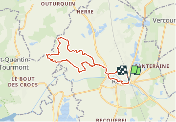
Trail Nordic walking of 13.5 km to be discovered at Hauts-de-France, Somme, Rue. This trail is proposed by denissculier.

Description

Un parcours culturel avec le riche passé de Rue et naturel avec le charme des terres plus basses que la mer.De cet ancien port au riche passé historique, partir vers les basses terres, sous le niveau de la mer, sillonnées de rus et de canaux.

Elevation profile

Positioning

Country:
France
Region :
Hauts-de-France
Department/Province :
Somme
Municipality :
Rue
Location:
Unknown
Start:(UTM)
405616 ; 5569813 (31U) N.


Close
My subscriptions