Trail Nordic walking Ponthoile - Les 400 coups - Photo
© OpenStreetMap contributors
Length
Length
11.9 km
Max alt
Max alt
20 m
Uphill gradient
Uphill gradient
49 m
Km-Effort
Km-Effort  
12.6 km
Min alt
Min alt
1 m
Downhill gradient
Downhill gradient
48 m
Boucle
Boucle
Yes
Creation date :
2019-06-13 15:34:08.751
Updated on :
2021-02-24 17:08:57.538

(0 Reviews)

Nordic walking
Nordic walking
2h51
Difficulty : Medium

Scan this QR Code to open this trail in the SityTrail application

FREE GPS app for hiking

Logo SityTrail SityTrail

IGN / Geographical institutes

Download SityTrail from the App Store Download SityTrail from Google Play

Logo SityTrail SityTrail Plus

The world is yours!

Download SityTrail from the App Store Download SityTrail from Google Play Download SityTrail on Huawei AppGallery

About

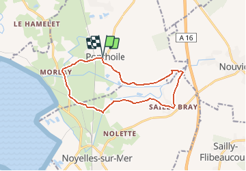
Trail Nordic walking of 11.9 km to be discovered at Hauts-de-France, Somme, Ponthoile. This trail is proposed by denissculier.

Description

Vous aimerez le retour au point de départ : une aire de pique-nique au cœur du village avec un petit café encore ouvert !Une balade dans la petite vallée de deux rivières, le Dien et les Iles, alimentant un marais envié par de nombreux huttiers.

Elevation profile

Positioning

Country:
France
Region :
Hauts-de-France
Department/Province :
Somme
Municipality :
Ponthoile
Location:
Unknown
Start:(UTM)
407992 ; 5563337 (31U) N.


Close
My subscriptions