


Ranc Chabrier

pb07
User
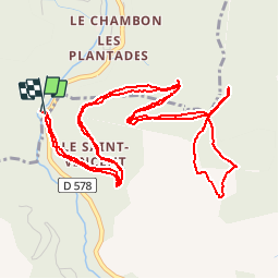

Length
7.7 km

Max alt
909 m

Uphill gradient
361 m
Km-Effort
12.5 km

Min alt
568 m

Downhill gradient
360 m
Boucle
Yes
Creation date :
2019-06-13 13:10:05.341
Updated on :
2019-06-13 15:46:40.183
2h35
Difficulty : Difficult

FREE GPS app for hiking
 SityTrail
IGN / Geographical institutes
SityTrail Plus
The world is yours!
About
Trail Walking of 7.7 km to be discovered at Auvergne-Rhône-Alpes, Ardèche, Laviolle. This trail is proposed by pb07.
Positioning
Country:
France
Region :
Auvergne-Rhône-Alpes
Department/Province :
Ardèche
Municipality :
Laviolle
Location:
Unknown
Start:(Dec)
Start:(UTM)
606023 ; 4955573 (31T) N.
Comments