


mandailles refuge meige coste

claudel
User
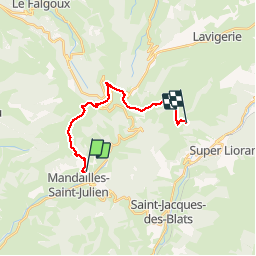

Length
15.3 km

Max alt
1729 m

Uphill gradient
1035 m
Km-Effort
28 km

Min alt
1049 m

Downhill gradient
637 m
Boucle
No
Creation date :
2019-06-13 07:30:06.203
Updated on :
2019-06-13 16:59:15.369
9h03
Difficulty : Very easy

FREE GPS app for hiking
 SityTrail
IGN / Geographical institutes
SityTrail Plus
The world is yours!
About
Trail Walking of 15.3 km to be discovered at Auvergne-Rhône-Alpes, Cantal, Mandailles-Saint-Julien. This trail is proposed by claudel.
Positioning
Country:
France
Region :
Auvergne-Rhône-Alpes
Department/Province :
Cantal
Municipality :
Mandailles-Saint-Julien
Location:
Unknown
Start:(Dec)
Start:(UTM)
472839 ; 4991130 (31T) N.
Comments