


SAINT GENIEZ Montagne de Dromond. La baleine o

RobinMicheline
User GUIDE
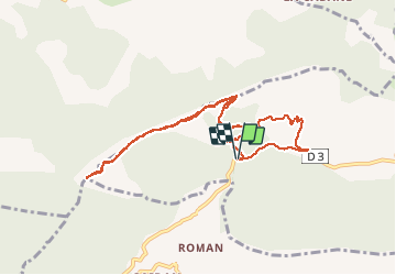

Length
10 km

Max alt
1336 m

Uphill gradient
416 m
Km-Effort
15.5 km

Min alt
1024 m

Downhill gradient
408 m
Boucle
Yes
Creation date :
2019-06-12 07:37:35.587
Updated on :
2020-01-22 19:18:10.618
4h18
Difficulty : Medium

FREE GPS app for hiking
 SityTrail
IGN / Geographical institutes
SityTrail Plus
The world is yours!
About
Trail Walking of 10 km to be discovered at Provence-Alpes-Côte d'Azur, Alpes-de-Haute-Provence, Saint-Geniez. This trail is proposed by RobinMicheline.
Description
3 H 40 10 kms 400 me magnifique
Positioning
Country:
France
Region :
Provence-Alpes-Côte d'Azur
Department/Province :
Alpes-de-Haute-Provence
Municipality :
Saint-Geniez
Location:
Unknown
Start:(Dec)
Start:(UTM)
261197 ; 4902326 (32T) N.
Comments