


RS-Beaucroissant-Les étangs

raymondfn
User
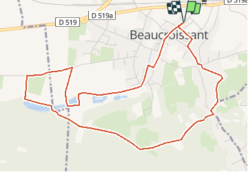

Length
6.1 km

Max alt
477 m

Uphill gradient
75 m
Km-Effort
7.1 km

Min alt
420 m

Downhill gradient
75 m
Boucle
Yes
Creation date :
2019-06-14 13:52:12.484
Updated on :
2021-01-07 15:22:19.284
47m
Difficulty : Easy

FREE GPS app for hiking
 SityTrail
IGN / Geographical institutes
SityTrail Plus
The world is yours!
About
Trail Walking of 6.1 km to be discovered at Auvergne-Rhône-Alpes, Isère, Beaucroissant. This trail is proposed by raymondfn.
Description
Rando Santé
Positioning
Country:
France
Region :
Auvergne-Rhône-Alpes
Department/Province :
Isère
Municipality :
Beaucroissant
Location:
Unknown
Start:(Dec)
Start:(UTM)
693698 ; 5023906 (31T) N.
Comments