


9792168-ECAULT FORET

denissculier
User
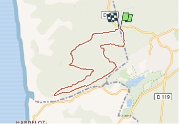

Length
7.2 km

Max alt
66 m

Uphill gradient
76 m
Km-Effort
8.2 km

Min alt
15 m

Downhill gradient
76 m
Boucle
Yes
Creation date :
2019-06-14 15:54:59.904
Updated on :
2019-12-13 09:12:35.962
1h45
Difficulty : Medium

FREE GPS app for hiking
 SityTrail
IGN / Geographical institutes
SityTrail Plus
The world is yours!
About
Trail Nordic walking of 7.2 km to be discovered at Hauts-de-France, Pas-de-Calais, Condette. This trail is proposed by denissculier.
Positioning
Country:
France
Region :
Hauts-de-France
Department/Province :
Pas-de-Calais
Municipality :
Condette
Location:
Unknown
Start:(Dec)
Start:(UTM)
401644 ; 5612411 (31U) N.
Comments