


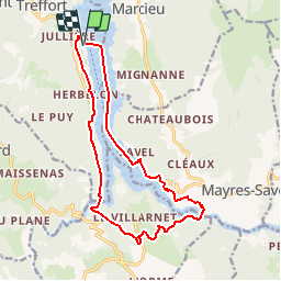
Les Passerelles Hymalaiennes par Treffort

claude nier
User

Length
15.7 km

Max alt
695 m

Uphill gradient
484 m
Km-Effort
22 km

Min alt
469 m

Downhill gradient
485 m
Boucle
Yes
Creation date :
2019-06-15 11:35:13.889
Updated on :
2019-06-15 11:36:30.227
4h39
Difficulty : Very difficult

FREE GPS app for hiking
 SityTrail
IGN / Geographical institutes
SityTrail Plus
The world is yours!
About
Trail Walking of 15.7 km to be discovered at Auvergne-Rhône-Alpes, Isère, Treffort. This trail is proposed by claude nier.
Description
belle rando normal c est le Bled ....
Positioning
Country:
France
Region :
Auvergne-Rhône-Alpes
Department/Province :
Isère
Municipality :
Treffort
Location:
Unknown
Start:(Dec)
Start:(UTM)
710905 ; 4976067 (31T) N.
Comments