


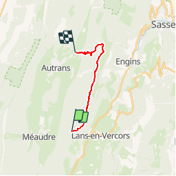
Croix Perrin

jacques.seux
User

Length
12.3 km

Max alt
1714 m

Uphill gradient
554 m
Km-Effort
20 km

Min alt
1090 m

Downhill gradient
696 m
Boucle
No
Creation date :
2019-06-15 13:20:09.208
Updated on :
2019-06-15 13:27:37.59
3h08
Difficulty : Difficult

FREE GPS app for hiking
 SityTrail
IGN / Geographical institutes
SityTrail Plus
The world is yours!
About
Trail Walking of 12.3 km to be discovered at Auvergne-Rhône-Alpes, Isère, Lans-en-Vercors. This trail is proposed by jacques.seux.
Positioning
Country:
France
Region :
Auvergne-Rhône-Alpes
Department/Province :
Isère
Municipality :
Lans-en-Vercors
Location:
Unknown
Start:(Dec)
Start:(UTM)
701320 ; 5000650 (31T) N.
Comments