


Essoyes

maxEA65
User
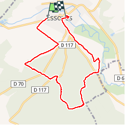

Length
8.9 km

Max alt
279 m

Uphill gradient
160 m
Km-Effort
11 km

Min alt
181 m

Downhill gradient
165 m
Boucle
No
Creation date :
2019-06-15 12:21:32.651
Updated on :
2019-06-15 15:10:25.197
2h48
Difficulty : Very easy

FREE GPS app for hiking
 SityTrail
IGN / Geographical institutes
SityTrail Plus
The world is yours!
About
Trail Walking of 8.9 km to be discovered at Grand Est, Aube, Essoyes. This trail is proposed by maxEA65.
Description
Renoir
Positioning
Country:
France
Region :
Grand Est
Department/Province :
Aube
Municipality :
Essoyes
Location:
Unknown
Start:(Dec)
Start:(UTM)
614063 ; 5323784 (31U) N.
Comments