


CC_Velay_BB_06_Nasbinals_St-Chely-Aubrac_20070820

patrickdanilo
User
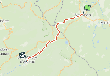

Length
17.1 km

Max alt
1369 m

Uphill gradient
314 m
Km-Effort
22 km

Min alt
792 m

Downhill gradient
658 m
Boucle
No
Creation date :
2019-06-15 16:37:18.487
Updated on :
2022-08-11 10:49:11.147
5h30
Difficulty : Easy

FREE GPS app for hiking
 SityTrail
IGN / Geographical institutes
SityTrail Plus
The world is yours!
About
Trail Walking of 17.1 km to be discovered at Occitania, Lozère, Nasbinals. This trail is proposed by patrickdanilo.
Description
Randonnée Marche de 17,1 km à découvrir à Occitanie, Lozère, Nasbinals. Cette randonnée est proposée par patrickdanilo.
Photos


Positioning
Country:
France
Region :
Occitania
Department/Province :
Lozère
Municipality :
Nasbinals
Location:
Unknown
Start:(Dec)
Start:(UTM)
503727 ; 4945463 (31T) N.
Comments