


Pointe sable

sameja
User
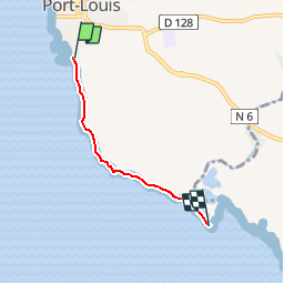

Length
4.3 km

Max alt
7 m

Uphill gradient
29 m
Km-Effort
4.7 km

Min alt
0 m

Downhill gradient
29 m
Boucle
No
Creation date :
2019-06-16 02:43:24.754
Updated on :
2019-06-17 00:52:08.864
1h02
Difficulty : Easy
FREE GPS app for hiking
 SityTrail
IGN / Geographical institutes
SityTrail Plus
The world is yours!
About
Trail Walking of 4.3 km to be discovered at Guadeloupe, Unknown, Port-Louis. This trail is proposed by sameja.
Description
le litoral PORT LOUIS/ PETIT CANAL
Positioning
Country:
France
Region :
Guadeloupe
Department/Province :
Unknown
Municipality :
Port-Louis
Location:
Unknown
Start:(Dec)
Start:(UTM)
656983 ; 1814897 (20Q) N.
Comments