


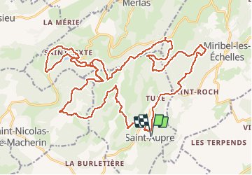
Rando du Hibou.Mud race

StephaneBM
User

Length
34 km

Max alt
911 m

Uphill gradient
1205 m
Km-Effort
50 km

Min alt
466 m

Downhill gradient
1205 m
Boucle
Yes
Creation date :
2019-06-16 07:14:10.149
Updated on :
2019-06-16 11:41:15.529
4h25
Difficulty : Difficult

FREE GPS app for hiking
 SityTrail
IGN / Geographical institutes
SityTrail Plus
The world is yours!
About
Trail Mountain bike of 34 km to be discovered at Auvergne-Rhône-Alpes, Isère, Saint-Aupre. This trail is proposed by StephaneBM.
Positioning
Country:
France
Region :
Auvergne-Rhône-Alpes
Department/Province :
Isère
Municipality :
Saint-Aupre
Location:
Unknown
Start:(Dec)
Start:(UTM)
709045 ; 5030725 (31T) N.
Comments