


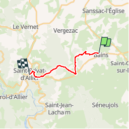
bains_st privat d allier

doboul
User

Length
12.3 km

Max alt
1215 m

Uphill gradient
267 m
Km-Effort
16.2 km

Min alt
872 m

Downhill gradient
374 m
Boucle
No
Creation date :
2019-06-17 07:36:26.912
Updated on :
2019-06-17 11:34:38.603
3h55
Difficulty : Very easy

FREE GPS app for hiking
 SityTrail
IGN / Geographical institutes
SityTrail Plus
The world is yours!
About
Trail Walking of 12.3 km to be discovered at Auvergne-Rhône-Alpes, Haute-Loire, Bains. This trail is proposed by doboul.
Positioning
Country:
France
Region :
Auvergne-Rhône-Alpes
Department/Province :
Haute-Loire
Municipality :
Bains
Location:
Unknown
Start:(Dec)
Start:(UTM)
560941 ; 4984371 (31T) N.
Comments