


randonnée scolaire

bidetarou
User
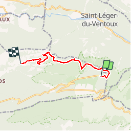

Length
9.7 km

Max alt
1425 m

Uphill gradient
36 m
Km-Effort
13 km

Min alt
604 m

Downhill gradient
856 m
Boucle
No
Creation date :
2019-06-17 08:31:38.144
Updated on :
2019-06-17 13:14:18.219
4h24
Difficulty : Medium

FREE GPS app for hiking
 SityTrail
IGN / Geographical institutes
SityTrail Plus
The world is yours!
About
Trail Walking of 9.7 km to be discovered at Provence-Alpes-Côte d'Azur, Vaucluse, Beaumont-du-Ventoux. This trail is proposed by bidetarou.
Positioning
Country:
France
Region :
Provence-Alpes-Côte d'Azur
Department/Province :
Vaucluse
Municipality :
Beaumont-du-Ventoux
Location:
Unknown
Start:(Dec)
Start:(UTM)
681945 ; 4894859 (31T) N.
Comments