


tour du col du singe

GuySimonin
User
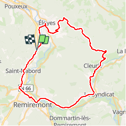

Length
35 km

Max alt
805 m

Uphill gradient
653 m
Km-Effort
44 km

Min alt
368 m

Downhill gradient
655 m
Boucle
Yes
Creation date :
2019-06-17 15:20:35.774
Updated on :
2019-06-17 17:26:15.395
2h04
Difficulty : Medium

FREE GPS app for hiking
 SityTrail
IGN / Geographical institutes
SityTrail Plus
The world is yours!
About
Trail Road bike of 35 km to be discovered at Grand Est, Vosges, Saint-Nabord. This trail is proposed by GuySimonin.
Description
vélo beau temps
Positioning
Country:
France
Region :
Grand Est
Department/Province :
Vosges
Municipality :
Saint-Nabord
Location:
Unknown
Start:(Dec)
Start:(UTM)
321058 ; 5326484 (32U) N.
Comments