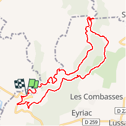
Le canyon de la Louyre, de l'Échelette à l'Évent des Grenouillettes

Nathy8913
User

Length
10.9 km

Max alt
381 m

Uphill gradient
217 m
Km-Effort
13.8 km

Min alt
215 m

Downhill gradient
213 m
Boucle
Yes
Creation date :
2019-06-18 21:05:18.203
Updated on :
2019-06-18 21:05:32.575

FREE GPS app for hiking
 SityTrail
IGN / Geographical institutes
SityTrail Plus
The world is yours!
About
Trail of 10.9 km to be discovered at Auvergne-Rhône-Alpes, Ardèche, Lussas. This trail is proposed by Nathy8913.
Points of interest


Positioning
Country:
France
Region :
Auvergne-Rhône-Alpes
Department/Province :
Ardèche
Municipality :
Lussas
Location:
Unknown
Start:(Dec)
Start:(UTM)
614282 ; 4941594 (31T) N.
Comments