


Champ feu

jcm17
User

Length
10.7 km

Max alt
1089 m

Uphill gradient
454 m
Km-Effort
15.9 km

Min alt
684 m

Downhill gradient
203 m
Boucle
No
Creation date :
2019-06-19 07:57:29.961
Updated on :
2019-06-19 15:15:47.66
6h12
Difficulty : Very easy

FREE GPS app for hiking
 SityTrail
IGN / Geographical institutes
SityTrail Plus
The world is yours!
About
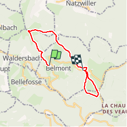
Trail Walking of 10.7 km to be discovered at Grand Est, Bas-Rhin, Belmont. This trail is proposed by jcm17.
Positioning
Country:
France
Region :
Grand Est
Department/Province :
Bas-Rhin
Municipality :
Belmont
Location:
Unknown
Start:(Dec)
Start:(UTM)
369193 ; 5363356 (32U) N.
Comments