


Tuc de Labassé

mitch1952
User
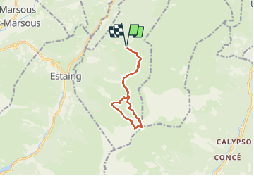

Length
10.6 km

Max alt
2184 m

Uphill gradient
771 m
Km-Effort
21 km

Min alt
1470 m

Downhill gradient
772 m
Boucle
Yes
Creation date :
2019-06-19 16:33:39.565
Updated on :
2022-06-01 19:00:47.176
4h44
Difficulty : Very difficult

FREE GPS app for hiking
 SityTrail
IGN / Geographical institutes
SityTrail Plus
The world is yours!
About
Trail Walking of 10.6 km to be discovered at Occitania, Hautespyrenees, Arras-en-Lavedan. This trail is proposed by mitch1952.
Positioning
Country:
France
Region :
Occitania
Department/Province :
Hautespyrenees
Municipality :
Arras-en-Lavedan
Location:
Unknown
Start:(Dec)
Start:(UTM)
732649 ; 4759296 (30T) N.
Comments