


Retour Colo Les Fontenotte1s

norbertmarteau
User

Length
7.7 km

Max alt
1095 m

Uphill gradient
107 m
Km-Effort
10 km

Min alt
751 m

Downhill gradient
369 m
Boucle
No
Creation date :
2014-12-10 00:00:00.0
Updated on :
2014-12-10 00:00:00.0
2h06
Difficulty : Easy

FREE GPS app for hiking
 SityTrail
IGN / Geographical institutes
SityTrail Plus
The world is yours!
About
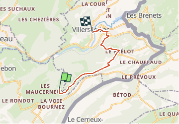
Trail Walking of 7.7 km to be discovered at Bourgogne-Franche-Comté, Doubs, Montlebon. This trail is proposed by norbertmarteau.
Positioning
Country:
France
Region :
Bourgogne-Franche-Comté
Department/Province :
Doubs
Municipality :
Montlebon
Location:
Unknown
Start:(Dec)
Start:(UTM)
321279 ; 5211540 (32T) N.
Comments