


CC_Velay_EE_21_Castelnau-Auvignon_Montreal_20080821

patrickdanilo
User
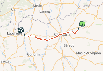

Length
26 km

Max alt
180 m

Uphill gradient
442 m
Km-Effort
32 km

Min alt
72 m

Downhill gradient
461 m
Boucle
No
Creation date :
2019-06-20 18:15:21.736
Updated on :
2022-09-17 14:33:17.619
6h54
Difficulty : Easy

FREE GPS app for hiking
 SityTrail
IGN / Geographical institutes
SityTrail Plus
The world is yours!
About
Trail Walking of 26 km to be discovered at Occitania, Gers, Castelnau-sur-l'Auvignon. This trail is proposed by patrickdanilo.
Description
Randonnée Marche de 26 km à découvrir à Occitanie, Gers, Castelnau-sur-l'Auvignon. Cette randonnée est proposée par patrickdanilo.
Photos


Positioning
Country:
France
Region :
Occitania
Department/Province :
Gers
Municipality :
Castelnau-sur-l'Auvignon
Location:
Unknown
Start:(Dec)
Start:(UTM)
295723 ; 4871745 (31T) N.
Comments