


26 La Jarjatte circuit cascade gc

guy07
User
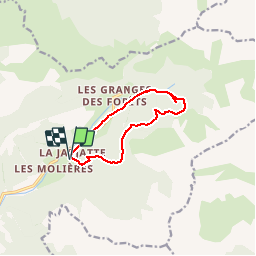

Length
9.6 km

Max alt
1563 m

Uphill gradient
462 m
Km-Effort
15.7 km

Min alt
1155 m

Downhill gradient
464 m
Boucle
Yes
Creation date :
2019-06-22 06:34:20.589
Updated on :
2019-06-22 06:37:24.998
3h13
Difficulty : Difficult

FREE GPS app for hiking
 SityTrail
IGN / Geographical institutes
SityTrail Plus
The world is yours!
About
Trail Walking of 9.6 km to be discovered at Auvergne-Rhône-Alpes, Drôme, Lus-la-Croix-Haute. This trail is proposed by guy07.
Positioning
Country:
France
Region :
Auvergne-Rhône-Alpes
Department/Province :
Drôme
Municipality :
Lus-la-Croix-Haute
Location:
Unknown
Start:(Dec)
Start:(UTM)
718569 ; 4950466 (31T) N.
Comments
cirque de montagnes. alternance de vue et de parties boisées. passage dans un permafrost!!!