Trail Electric bike Saint-Antoine - Saint Antoine -Condom 22/06/2019 - Photo

Saint Antoine -Condom 22/06/2019

© OpenStreetMap contributors
Length
Length
53 km
Max alt
Max alt
215 m
Uphill gradient
Uphill gradient
867 m
Km-Effort
Km-Effort  
65 km
Min alt
Min alt
71 m
Downhill gradient
Downhill gradient
933 m
Boucle
Boucle
No
Creation date :
2019-06-22 07:04:32.0
Updated on :
2020-05-23 17:22:37.544

(0 Reviews)

Electric bike
Electric bike
3h11
Difficulty : Difficult

Scan this QR Code to open this trail in the SityTrail application

FREE GPS app for hiking

Logo SityTrail SityTrail

IGN / Geographical institutes

Download SityTrail from the App Store Download SityTrail from Google Play

Logo SityTrail SityTrail World

The world is yours!

Download SityTrail from the App Store Download SityTrail from Google Play Download SityTrail on Huawei AppGallery

About

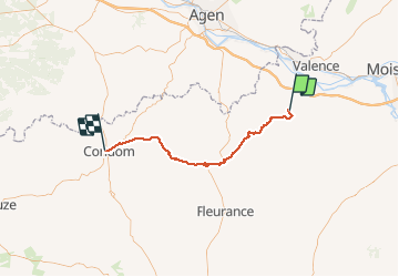
Trail Electric bike of 53 km to be discovered at Occitania, Gers, Saint-Antoine. This trail is proposed by zoe.vienne.

Description

Chemin de Saint Jacques, troisième étape, 53km bien vallonné 😅

Elevation profile

Photos

Positioning

Country:
France
Region :
Occitania
Department/Province :
Gers
Municipality :
Saint-Antoine
Location:
Unknown
Start:(UTM)
325557 ; 4877601 (31T) N.

Trails nearby

Trail Walking Saint-Antoine - CC_Velay_EC_19_St-Antoine_Lectoure_20080819 - Photo
Walking
patrickdanilo

Walking

Medium
Saint-Antoine, Occitania, Gers, France
25 km | 32 km-effort
6h 53min
No
Trail Walking Saint-Antoine - Saint Antoine - Lectoure - Chemin de Compostelle - Photo
Walking
tracegps

Walking

Very difficult
(1)
Saint-Antoine, Occitania, Gers, France
24 km | 31 km-effort
9h 34min
No
Trail Walking Bardigues - compostelle 2023 étape 9 le 27 avril 2023  Bardigues - Espasot - Photo
Walking
Christianlabourie

Walking

Very difficult
Bardigues, Occitania, Tarn-et-Garonne, France
35 km | 44 km-effort
9h 51min
No
Trail Walking Saint-Antoine - 32_Castet_Arrouy - Photo
Walking
jab31

Walking

Easy
Saint-Antoine, Occitania, Gers, France
13.5 km | 17.7 km-effort
3h 51min
No
Trail Walking Saint-Antoine - StJ-J34-St Antoine-Lectoure - Photo
Walking
Bonsaicd

Walking

Very difficult
Saint-Antoine, Occitania, Gers, France
25 km | 32 km-effort
6h 53min
No
Trail Walking Saint-Antoine - OR-6939902--Saint-Antoine:saint antoine-lectoure-2 - Photo
Walking
Compostel61

Walking

Very easy
Saint-Antoine, Occitania, Gers, France
25 km | 32 km-effort
6h 49min
No
Trail Walking Flamarens - Flamarens-Lectoure - Photo
Walking
sgazaix

Walking

Very difficult
Flamarens, Occitania, Gers, France
22 km | 27 km-effort
6h 11min
No
Trail Walking Saint-Antoine - ferme de Villeneuve-lectoure - Photo
Walking
bernard.bonafous@free.fr

Walking

Very difficult
Saint-Antoine, Occitania, Gers, France
26 km | 33 km-effort
6h 32min
No
Trail Walking Mansonville - 70_15_03_Mansonville Lectoure - Photo
Walking
jeanlucien

Walking

Difficult
Mansonville, Occitania, Tarn-et-Garonne, France
25 km | 32 km-effort
6h 0min
No


Close
My subscriptions