rochegude mercoeur

doboul
User
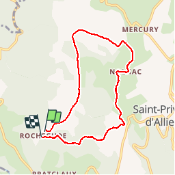

Length
7.9 km

Max alt
1078 m

Uphill gradient
187 m
Km-Effort
10.5 km

Min alt
884 m

Downhill gradient
212 m
Boucle
Yes
Creation date :
2019-06-25 07:25:06.076
Updated on :
2019-06-25 09:27:25.956
2h01
Difficulty : Very easy

FREE GPS app for hiking
 SityTrail
IGN / Geographical institutes
SityTrail Plus
The world is yours!
About
Trail Walking of 7.9 km to be discovered at Auvergne-Rhône-Alpes, Haute-Loire, Saint-Privat-d'Allier. This trail is proposed by doboul.
Positioning
Country:
France
Region :
Auvergne-Rhône-Alpes
Department/Province :
Haute-Loire
Municipality :
Saint-Privat-d'Allier
Location:
Saint-Privat-d'Allier
Start:(Dec)
Start:(UTM)
551169 ; 4981745 (31T) N.
Comments