


arc sous cicon, plaine

eltonnermou
User
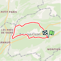

Length
10.8 km

Max alt
922 m

Uphill gradient
222 m
Km-Effort
13.7 km

Min alt
785 m

Downhill gradient
223 m
Boucle
Yes
Creation date :
2019-06-26 07:30:45.306
Updated on :
2019-06-29 07:45:37.931
1h39
Difficulty : Very easy

FREE GPS app for hiking
 SityTrail
IGN / Geographical institutes
SityTrail Plus
The world is yours!
About
Trail Walking of 10.8 km to be discovered at Bourgogne-Franche-Comté, Doubs, Arc-sous-Cicon. This trail is proposed by eltonnermou.
Description
Randonnée pieds propres (hors période neigeuse).
découvrir la plaine et les sous bois de ce joli village.
Positioning
Country:
France
Region :
Bourgogne-Franche-Comté
Department/Province :
Doubs
Municipality :
Arc-sous-Cicon
Location:
Unknown
Start:(Dec)
Start:(UTM)
303215 ; 5213889 (32T) N.
Comments