


Fort Mahon

FPortier
User
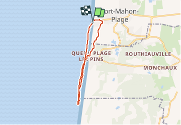

Length
9.6 km

Max alt
17 m

Uphill gradient
30 m
Km-Effort
10 km

Min alt
-1 m

Downhill gradient
31 m
Boucle
Yes
Creation date :
2019-06-29 06:59:44.411
Updated on :
2019-07-01 13:02:38.981
4h07
Difficulty : Very easy

FREE GPS app for hiking
 SityTrail
IGN / Geographical institutes
SityTrail Plus
The world is yours!
About
Trail Walking of 9.6 km to be discovered at Hauts-de-France, Somme, Fort-Mahon-Plage. This trail is proposed by FPortier.
Description
balade bord de mer
Positioning
Country:
France
Region :
Hauts-de-France
Department/Province :
Somme
Municipality :
Fort-Mahon-Plage
Location:
Unknown
Start:(Dec)
Start:(UTM)
396798 ; 5577173 (31U) N.
Comments