Trail Walking Joué-du-Bois - La Raitiere  - Photo
© OpenStreetMap contributors
Length
Length
2.8 km
Max alt
Max alt
313 m
Uphill gradient
Uphill gradient
67 m
Km-Effort
Km-Effort  
3.7 km
Min alt
Min alt
256 m
Downhill gradient
Downhill gradient
77 m
Boucle
Boucle
No
Creation date :
2019-07-01 13:21:07.5
Updated on :
2019-07-01 18:24:59.994

(0 Reviews)

Walking
Walking
1h51
Difficulty : Very easy

Scan this QR Code to open this trail in the SityTrail application

FREE GPS app for hiking

Logo SityTrail SityTrail

IGN / Geographical institutes

Download SityTrail from the App Store Download SityTrail from Google Play

Logo SityTrail SityTrail World

The world is yours!

Download SityTrail from the App Store Download SityTrail from Google Play Download SityTrail on Huawei AppGallery

About

Trail Walking of 2.8 km to be discovered at Normandy, Orne, Joué-du-Bois. This trail is proposed by Elisabeth Neveu.

Description

rando 15 km de Bagnoles

Elevation profile

Positioning

Country:
France
Region :
Normandy
Department/Province :
Orne
Municipality :
Joué-du-Bois
Location:
Unknown
Start:(UTM)
704544 ; 5387625 (30U) N.

Trails nearby

Trail Walking Le Champ-de-la-Pierre - Le Champ de la pierre  - Photo
Walking
Roulland

Walking

Easy
Le Champ-de-la-Pierre, Normandy, Orne, France
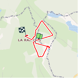
9.3 km | 11.4 km-effort
2h 59min
Yes
Trail Walking La Chaux - la chaux - Photo
Walking
magny

Walking

Very easy
La Chaux, Normandy, Orne, France
12.5 km | 15.2 km-effort
2h 20min
Yes
Trail Walking Joué-du-Bois - Joué du Bois (Boucle) - Photo
Walking
neitag61

Walking

Medium
Joué-du-Bois, Normandy, Orne, France
23 km | 27 km-effort
5h 30min
Yes


Close
My subscriptions