


lac de lignin

CASSISFRAMBOISE
User
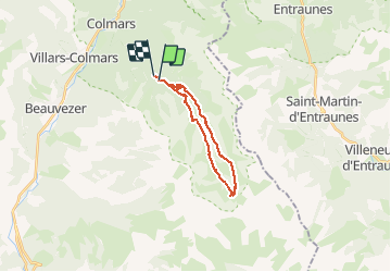

Length
18.1 km

Max alt
2293 m

Uphill gradient
690 m
Km-Effort
27 km

Min alt
1641 m

Downhill gradient
722 m
Boucle
No
Creation date :
2019-07-01 04:49:12.461
Updated on :
2019-07-02 14:27:38.506
5h17
Difficulty : Medium

FREE GPS app for hiking
 SityTrail
IGN / Geographical institutes
SityTrail Plus
The world is yours!
About
Trail Walking of 18.1 km to be discovered at Provence-Alpes-Côte d'Azur, Alpes-de-Haute-Provence, Colmars. This trail is proposed by CASSISFRAMBOISE.
Description
superbes vues...chemins et sentiers agreables
Positioning
Country:
France
Region :
Provence-Alpes-Côte d'Azur
Department/Province :
Alpes-de-Haute-Provence
Municipality :
Colmars
Location:
Unknown
Start:(Dec)
Start:(UTM)
312732 ; 4891811 (32T) N.
Comments