


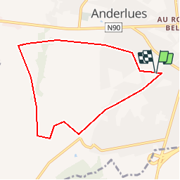
Anderlues terrain de foot rue de maubeuge

jackcox
User

Length
7.1 km

Max alt
204 m

Uphill gradient
52 m
Km-Effort
7.8 km

Min alt
167 m

Downhill gradient
53 m
Boucle
Yes
Creation date :
2019-07-03 14:43:54.155
Updated on :
2019-07-03 14:46:11.413
2h00
Difficulty : Very easy

FREE GPS app for hiking
 SityTrail
IGN / Geographical institutes
SityTrail Plus
The world is yours!
About
Trail Nordic walking of 7.1 km to be discovered at Wallonia, Hainaut, Anderlues. This trail is proposed by jackcox.
Positioning
Country:
Belgium
Region :
Wallonia
Department/Province :
Hainaut
Municipality :
Anderlues
Location:
Anderlues
Start:(Dec)
Start:(UTM)
590870 ; 5583733 (31U) N.
Comments