Trail Walking Ceillac - GR 58 Tour du Queyras - Photo
© OpenStreetMap contributors
Length
Length
132 km
Max alt
Max alt
3078 m
Uphill gradient
Uphill gradient
8556 m
Km-Effort
Km-Effort  
246 km
Min alt
Min alt
1188 m
Downhill gradient
Downhill gradient
8556 m
Boucle
Boucle
Yes
Creation date :
2019-06-23 06:41:24.352
Updated on :
2019-07-03 15:42:03.558

(0 Reviews)

Walking
Walking
71h22
Difficulty : Difficult

Scan this QR Code to open this trail in the SityTrail application

FREE GPS app for hiking

Logo SityTrail SityTrail

IGN / Geographical institutes

Download SityTrail from the App Store Download SityTrail from Google Play

Logo SityTrail SityTrail World

The world is yours!

Download SityTrail from the App Store Download SityTrail from Google Play Download SityTrail on Huawei AppGallery

About

Trail Walking of 132 km to be discovered at Provence-Alpes-Côte d'Azur, Hautes-Alpes, Ceillac. This trail is proposed by grattounette.

Description

départ de Ceillac, vers le col des estronques arrive a st Veran, col de chamoussiere et refuge Agnel , col vieux , a voir le pain de sucre. redescendre par les lacs de foreant et egorgeou, l'echalp , monté par monta variante du GR , direction crête de peyra plata , abries.le malrif, les Bertin,et le lac du malrif , (lac le grand mais)col du malrif, et les fonts de cervieres,col de pas,le souliers puis col Tronchet, brunissard, la chalp.ratraper le GR par le belvédère du coin,col de furfande, et refuge de furfande.les escoyeres, et bramousse.col fromage par la variante du GR58, col de bramousse, descente sur le village le Queyras et retour à Ceillac

Elevation profile

Positioning

Country:
France
Region :
Provence-Alpes-Côte d'Azur
Department/Province :
Hautes-Alpes
Municipality :
Ceillac
Location:
Unknown
Start:(UTM)
323683 ; 4948273 (32T) N.

Trails nearby

Trail Walking Ceillac - Crêtes de Chambrettes - Photo
Walking
GUIDE
amiral13

Walking

Medium
(1)
Ceillac, Provence-Alpes-Côte d'Azur, Hautes-Alpes, France
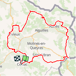
13.4 km | 26 km-effort
5h 53min
Yes
Trail Walking Ceillac - 05 Tour Font Sancte - étape 1 - Photo
Walking
Maryma

Walking

Very difficult
(1)
Ceillac, Provence-Alpes-Côte d'Azur, Hautes-Alpes, France
16.5 km | 36 km-effort
8h 9min
No
Trail Walking Vars - 05 Tour Font Sancte - étape 2 - Photo
Walking
Maryma

Walking

Very difficult
(1)
Vars, Provence-Alpes-Côte d'Azur, Hautes-Alpes, France
19 km | 38 km-effort
8h 41min
No
Trail Walking Ceillac - Ceillac - St Véran - Photo
Walking
GUIDE
romanceline

Walking

Medium
Ceillac, Provence-Alpes-Côte d'Azur, Hautes-Alpes, France
13.5 km | 28 km-effort
7h 22min
No
Trail Walking Ceillac - la pointe de la Saume (traversée) - Photo
Walking
GUIDE
amiral13

Walking

Difficult
Ceillac, Provence-Alpes-Côte d'Azur, Hautes-Alpes, France
15 km | 34 km-effort
6h 43min
No
Trail Walking Ceillac - Lac Ste Anne et Tête de Girardin - Photo
Walking
GUIDE
amiral13

Walking

Medium
Ceillac, Provence-Alpes-Côte d'Azur, Hautes-Alpes, France
14.4 km | 27 km-effort
5h 48min
Yes
Trail Walking Ceillac - lac Sainte Anne - Photo
Walking
griffet

Walking

Easy
(2)
Ceillac, Provence-Alpes-Côte d'Azur, Hautes-Alpes, France
10.7 km | 17.9 km-effort
5h 16min
No
Trail Walking Ceillac - #1 Queyras 3j étape 1 Ceillac - Lac de Roue - Photo
Walking
Liobric

Walking

Very difficult
Ceillac, Provence-Alpes-Côte d'Azur, Hautes-Alpes, France
16.7 km | 33 km-effort
7h 34min
No
Trail Walking Ceillac - Arvieux Randonnée - Photo
Walking
choumac08

Walking

Very difficult
Ceillac, Provence-Alpes-Côte d'Azur, Hautes-Alpes, France
138 km | 250 km-effort
56h 55min
Yes


Close
My subscriptions