


Madone d’Utelle

ajd26
User
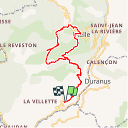

Length
20 km
Boucle
Yes
Creation date :
2019-07-03 05:49:52.0
Updated on :
2019-07-03 16:17:30.799
6h30
Difficulty : Difficult

FREE GPS app for hiking
 SityTrail
IGN / Geographical institutes
SityTrail Plus
The world is yours!
About
Trail Walking of 20 km to be discovered at Provence-Alpes-Côte d'Azur, Maritime Alps, Utelle. This trail is proposed by ajd26.
Description
Depuis le Croc d’Utuelle, chapelle St Antoine et sanctuaire de la Madone. Retour par Utuelle. Beaux paysages avec des sentiers en balcon
Photos


Positioning
Country:
France
Region :
Provence-Alpes-Côte d'Azur
Department/Province :
Maritime Alps
Municipality :
Utelle
Location:
Unknown
Start:(Dec)
Start:(UTM)
358350 ; 4860432 (32T) N.
Comments