NANT Le Liquier

limase
User
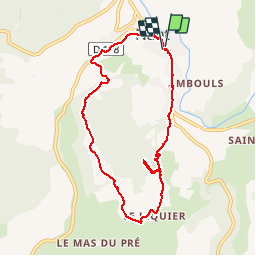

Length
8.2 km

Max alt
678 m

Uphill gradient
245 m
Km-Effort
11.4 km

Min alt
488 m

Downhill gradient
244 m
Boucle
Yes
Creation date :
2019-07-01 06:42:53.596
Updated on :
2019-07-05 05:14:52.478
3h14
Difficulty : Easy

FREE GPS app for hiking
 SityTrail
IGN / Geographical institutes
SityTrail Plus
The world is yours!
About
Trail Walking of 8.2 km to be discovered at Occitania, Aveyron, Nant. This trail is proposed by limase.
Positioning
Country:
France
Region :
Occitania
Department/Province :
Aveyron
Municipality :
Nant
Location:
Unknown
Start:(Dec)
Start:(UTM)
524330 ; 4874244 (31T) N.
Comments