


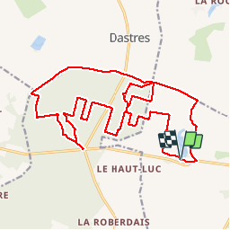
06/07/2019 - Etang de CLEGREUC & Forêt GAVRE nord.Virtuel

babeth35
User

Length
24 km

Max alt
75 m

Uphill gradient
225 m
Km-Effort
27 km

Min alt
40 m

Downhill gradient
225 m
Boucle
Yes
Creation date :
2019-07-06 14:02:37.012
Updated on :
2019-07-06 16:48:05.66
--
Difficulty : Medium
1m
Difficulty : Easy

FREE GPS app for hiking
 SityTrail
IGN / Geographical institutes
SityTrail Plus
The world is yours!
About
Trail On foot of 24 km to be discovered at Pays de la Loire, Loire-Atlantique, Vay. This trail is proposed by babeth35.
Positioning
Country:
France
Region :
Pays de la Loire
Department/Province :
Loire-Atlantique
Municipality :
Vay
Location:
Unknown
Start:(Dec)
Start:(UTM)
595493 ; 5267773 (30T) N.
Comments